Position: Home > > Measurement instrument > Length measuring instrument > Other Length area measuring instrument > RTS010A Robotic Total Station Measurement System

RTS010A Robotic Total Station Measurement System

Product ID:CLCDqtOther006

Price: Please inquire PDF Format
Supply Ability:50 SETS/MON
Port:SHENZHEN
  • Product Introduction
  • Other information
  • Model NumberRTS010A
    Brand NameSZYIGUANG
    Payment TermsTT,PAYPAL,Alibaba.com Pay
    RTS010A Robotic Total Station Measurement System
    Product Introduction
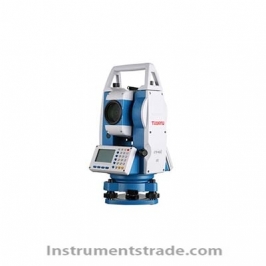
    The RTS010A Robotic Total Station Measurement System is a high-performance intelligent surveying instrument designed for automated precision measurement, engineering construction, land surveying, and mapping applications. Equipped with ATR automatic target recognition, servo motor drive technology, high-performance CPU, VGA color touch screen, and WINCE7.0 operating system, the RTS010A provides fast, accurate, and efficient measurement solutions.
    With a PC-style graphical interface, rich functional modules, and built-in surveying guidance programs, this automatic surveying robot system enables users to complete complex measurement tasks easily while improving field productivity and measurement accuracy.


    Key Performance Features
    •   ATR Automatic Target Recognition
      Automatically detects and locks targets with high positioning accuracy.
      ATR working range up to 700m.
    •   High Precision Angle Measurement
      Absolute encoder angle measurement technology.
      1″ angle measurement accuracy for precision surveying.
    •   Servo Motor Automatic Drive
      High-speed servo positioning system.
      Maximum rotation speed up to 35°/s.
      Supports automated target positioning and tracking.
    •   Advanced Operating System
     Built-in WINCE7.0 operating system.
     PC-style graphical touch interface for simple operation.
    •   Multiple Distance Measurement Modes
     Supports reflectorless, reflector sheet, and prism measurement.
     Reflectorless measurement range up to 1000m.
    •   Powerful Surveying Software
     Multiple application modules meet different surveying requirements.
     Provides measurement guidance for easier operation.
     Supports control commands and onboard software SDK.
    •   Reliable Field Performance
     IP55 dust and water resistance.
     Wide operating temperature range from -20℃ to +50℃.


    Working Principle
    The RTS010A robotic total station integrates electronic angle measurement, laser distance measurement, automatic target recognition (ATR), and servo motor positioning technologies.
    During operation, the instrument uses the ATR system to automatically identify and lock the target. The servo motors then adjust horizontal and vertical angles precisely to achieve automatic positioning. The electronic encoder measures angle changes, while the EDM (Electronic Distance Measurement) module calculates distance through laser reflection signals from prisms, reflector sheets, or natural surfaces.
    The collected angle and distance data are processed by the internal CPU and displayed through the touch-screen interface, providing accurate three-dimensional coordinate measurement results.


    Technical Parameters
    Category Parameter
    Telescope  
    Field of View 1°30′
    Minimum Focusing Distance 1.0m
    Image Erect
    Magnification 30X
    Resolution 3"
    Angle Measurement  
    Measurement Method Absolute Encoder
    Detection Method Diametrical Detection
    Angle Accuracy 1"
    Minimum Display 0.1"
    Distance Measurement  
    Reflectorless Accuracy 2mm + 2×10⁻⁶·D
    Reflector Sheet Accuracy 2mm + 2×10⁻⁶·D
    Prism Accuracy 1mm + 1×10⁻⁶·D
    Reflectorless Range 1000m
    Reflector Sheet Range 1200m
    Prism Range 5000m
    Fine Measurement Time <0.7s
    Compensator  
    Compensation Type Dual Axis
    Compensation Range ≥±3′
    Level System  
    Tubular Level 30″/2mm
    Circular Level 8′/2mm
    Laser Plummet  
    Laser Type 635nm Semiconductor Laser
    Accuracy ±1mm/1.5m
    Spot Size ≤2.5mm/0.5–2m
    ATR System  
    Working Range 5–700m
    Positioning Accuracy ±1mm@100m
    Positioning Time 3–4s
    Motor Drive  
    Servo Positioning Accuracy 3" (Standard Deviation)
    Maximum Rotation Speed 35°/s
    Minimum Slow Rotation Control 1"
    Display & Operation  
    Display Type Dual-side semi-transparent 3.5-inch 320×240 touch screen
    Keyboard Backlight + Automatic Light Sensor
    Operating System WINCE7.0
    Power Supply  
    Battery Type 7.4V 5.8Ah Lithium Battery
    Working Time 5–8h
    Environmental Performance  
    Protection Grade IP55 (IEC60529)
    Operating Temperature -20℃ to +50℃
    Storage Temperature -40℃ to +60℃
    Communication Interface RS232C, Mini USB, Bluetooth (Optional)
     

    Application Scenarios
    1. Engineering Construction Surveying
    Used for building layout, bridge construction, tunnel measurement, and infrastructure projects requiring high precision.
    2. Land Surveying and Mapping
    Provides accurate coordinate measurement for topographic surveys, cadastral mapping, and geographic information collection.
    3. Industrial Measurement
    Suitable for large equipment installation, deformation monitoring, and precision positioning tasks.
    4. Road and Railway Engineering
    Supports alignment measurement, elevation control, and construction inspection.
    5. Mining and Large-Scale Projects
    Provides efficient automated measurement solutions in complex outdoor environments.


    RTS010A Robotic Total Station vs Conventional Total Station
    Feature RTS010A Robotic Total Station Conventional Total Station
    Automatic Target Recognition ATR automatic aiming Manual target aiming required
    Motor Drive Servo motor automatic positioning Manual adjustment
    Angle Accuracy 1" Usually 2"–5"
    Reflectorless Range Up to 1000m Usually shorter
    Operation Interface Touch-screen graphical interface Traditional keypad operation
    Operating System WINCE7.0 intelligent system Basic embedded system
    Survey Efficiency High automation and fast measurement More operator dependent
    Software Expansion SDK and control command support Limited expansion capability
    The RTS010A combines robotic automation, high precision measurement, and intelligent software control, making it more efficient than traditional total stations for modern surveying projects.
     

    Frequently Asked Questions (FAQ)
    1. What is the RTS010A robotic total station used for?
    The RTS010A is mainly used for engineering surveying, land mapping, construction measurement, industrial positioning, and precision monitoring applications.
    2. Does the RTS010A support automatic target tracking?
    Yes. The RTS010A features ATR automatic target recognition technology, enabling automatic target detection and positioning.
    3. What is the maximum measurement range of the RTS010A?
    The RTS010A can measure up to 1000m without a prism, 1200m with a reflector sheet, and 5000m with a prism.
    4. What is the angle measurement accuracy of the RTS010A?
    The instrument provides 1" angle measurement accuracy with absolute encoder technology.
    5. Can the RTS010A work in harsh outdoor environments?
    Yes. It has an IP55 protection rating and operates from -20℃ to +50℃.
    6. What operating system does the RTS010A use?
    The RTS010A uses WINCE7.0 operating system with a graphical touch-screen interface.
    7. Does the RTS010A support external communication?
    Yes. It supports RS232C, mini USB, and optional Bluetooth communication.
    8. Can users develop customized software for the RTS010A?
    Yes. The system provides control commands and onboard software SDK for customization and integration.


    Product Summary
    The RTS010A Robotic Total Station Measurement System is an intelligent automatic surveying robot designed for high-precision measurement. With ATR auto targeting, servo motor control, 1″ accuracy, long-range EDM measurement, WINCE7.0 software platform, and rugged IP55 protection, it delivers reliable solutions for modern surveying, engineering construction, and industrial measurement applications.


  • Frequently Asked Questions (FAQ)
    1. What is the RTS010A robotic total station used for?
    The RTS010A is mainly used for engineering surveying, land mapping, construction measurement, industrial positioning, and precision monitoring applications.
    2. Does the RTS010A support automatic target tracking?
    Yes. The RTS010A features ATR automatic target recognition technology, enabling automatic target detection and positioning.
    3. What is the maximum measurement range of the RTS010A?
    The RTS010A can measure up to 1000m without a prism, 1200m with a reflector sheet, and 5000m with a prism.
    4. What is the angle measurement accuracy of the RTS010A?
    The instrument provides 1" angle measurement accuracy with absolute encoder technology.
    5. Can the RTS010A work in harsh outdoor environments?
    Yes. It has an IP55 protection rating and operates from -20℃ to +50℃.
    6. What operating system does the RTS010A use?
    The RTS010A uses WINCE7.0 operating system with a graphical touch-screen interface.
    7. Does the RTS010A support external communication?
    Yes. It supports RS232C, mini USB, and optional Bluetooth communication.
    8. Can users develop customized software for the RTS010A?
    Yes. The system provides control commands and onboard software SDK for customization and integration.

     
Products
Analytical instruments
Physical property test
Environmental monitoring and analysis
Lab general equipment
About us
About this website
Our service
Product purchase
Contact Us

Newsletter

Make Sure you dont miss interesting happenings by joining our newsletter program.

Contact Us
+86-18620722006
instruments@instrumentstrade.com