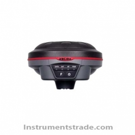
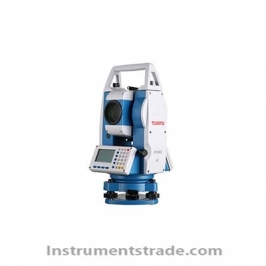
Introduction: The Model 810 Super Station is a newly developed collection of total station angle measurement function, range finder distance measurement function and GPS positioning function. It is not limited by time and region. It does not depend on the control network. There is no need to set up the base station. There is no working radius limitation. An integrated surveying and mapping instrument that can complete all mapping operations in a single machine. The Model 810 Super Station can be used for field measurements without control points. This mode of operation can greatly improve the traditional methods of operation, such as mine surveys, line surveys, and engineering stakeouts in remote mountainous and rural areas. The measurement work with high labor intensity such as topographic mapping, as well as the construction site and the rapidly developing urban area, can greatly improve work efficiency and save manpower and material resources. Features: WINCE intelligent True color touch screen Alignment guidance High speed 32-bit processor Technical Parameters: Total station part: Objective lens effective aperture: 45mm Tube length: 156mm Field of view: 1°30' Resolution: 3′′ Imaging: just like Magnification: 30X Shortest line of sight: 1.5m Minimum reading: 1′′/5′′ Angle measurement method: absolute coding Angle measurement accuracy: 2′′ Measuring range: 500m / prism free 800m / reflector 1200m/mini prism 5000m/single prism Precision measurement (prism): ±(2mm+2×10⁻⁶•D) Ranging time: 1S fine test mode Compensation range: ±3' Compensation type: Dual axis, liquid electronic sensor compensation 7.4V 4AH lithium battery Working time: 12h Waterproof and dustproof: IP54 Operating System: WinCE 5.0 Memory: 64MB RAM 32MB ROM Memory card: SD card 1024M Display: 3.5-inch screen, 320 × 240 (QVGA) color TFT touch screen I/O: USB, RS-232C, support GIS data upload and delivery, Bluetooth (optional) GPS part: RTK positioning accuracy: Plane: ±10mm+1×10⁻⁶ •D Elevation: ±20mm+1×10⁻⁶ •D Static accuracy: Plane: ±3mm+1×10⁻⁶ •D Elevation: ±5mm+1×10⁻⁶ •D Code differential positioning accuracy: 0.45 meters Stand-alone positioning accuracy: 1.5 meters Physical characteristics: 1. Three-proof industrial design (waterproof, shockproof, dustproof): IP67, resistant to 2 meters of natural fall 2. Display: 4 rows and 16 columns of OLED highlight display, 4 high-brightness LED display lights, Chinese/English interface display 3. Data storage: built-in 4G TF card 4. The capacity of single lithium battery is 5800mAh, the charger adopts double charging mode, the working time of single battery is more than 10 hours, and the standard is 2 pieces. Lithium battery, can work for more than 20 hours 5. Temperature: Working temperature: -40 °C <+80 °C, storage temperature: -55 °C <+85 °C 6. Voice prompt: Chinese/English prompt voice, live class through setting options
Introduction: The Model 810 Super Station is a newly developed collection of total station angle measurement function, range finder distance measurement function and GPS positioning function. It is not limited by time and region. It does not depend on the control network. There is no need to set up the base station. There is no working radius limitation. An integrated surveying and mapping instrument that can complete all mapping operations in a single machine. The Model 810 Super Station can be used for field measurements without control points. This mode of operation can greatly improve the traditional methods of operation, such as mine surveys, line surveys, and engineering stakeouts in remote mountainous and rural areas. The measurement work with high labor intensity such as topographic mapping, as well as the construction site and the rapidly developing urban area, can greatly improve work efficiency and save manpower and material resources.