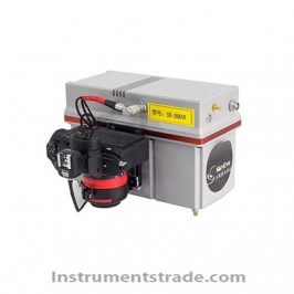
SE-J500C airborne laser radar system Introduction: SKYEYE SE-J500 unmanned airborne laser radar system, with long distance measurement and high precision, is suitable for unmanned airborne laser radar operation in hilly and mountainous areas. Integrated laser scanner, POS positioning and positioning system, high-resolution digital camera, embedded computer in one, one-button open, self-collecting and saving data. Simultaneous acquisition of 3D laser point clouds and true color images provides accurate and rich 3D geographic information data. According to the maximum detection distance, SE-J500 has SE-J500A, SE-J500B, SE-J500C and SE-J500D series to meet different terrain conditions. The SE-500C has a maximum detection range of up to 1350m and inertial navigation accuracy of 0.02°, 0.02°, and 0.045° (RMS) (R, P, H). It is after our company practiced about 400 laser radar applications in the hills. Very efficient and economical unmanned airborne lidar system in the mountainous region. Features: 1. High integration: small size, light weight, portable and easy to install on a variety of low-altitude flight platforms 2. High efficiency: the flight site is limited, 8-10km for one flight, 5-30 square kilometers per day. Simple operation: One button to open, self-collecting and saving data, one-button take-off and landing automatically execute the route 3. High precision: Accuracy meets 1:500 topographic mapping requirements 4. Vegetation penetrability: can penetrate the vegetation gap to obtain vegetation and the following accurate terrain three-dimensional information, suitable for dense vegetation areas 5. Real-time monitoring: Support point cloud data, POS parameters, device status display in real time during the operation process Technical Parameters: Product model: SE-J500C System weight (with battery): 7kg System volume: 510 mm × 180 mm × 200 mm Maximum detection distance (60% reflectivity): 1350m Laser wavelength (near infrared): 1550nm Laser pulse frequency: 50kHz~820kHz adjustable Scanning line speed: 10 Lines/s -200 Lines/s adjustable Scan angle range: 0~330° adjustable IMU attitude data refresh rate: 200Hz Attitude accuracy (RMS) (R, P, H): 0.02°, 0.02°, 0.045° GNSS receiving frequency: GPS L1 L2 L5, Beidou B1 B2, GLONASS L1 L2 Measurement accuracy @ working height (unit: m): 0.1@500 (elevation), 0.4@500 (flat) Image resolution (pixels): 6000 × 4000 (24 million) Camera parameters: 35mm focal length, pixel size 6.0um, photo interval 1-5 seconds / Zhang Working power supply: 12-24V DC Power consumption (max): 95W Working temperature: 0 °C ~ 40 °C Camera image format: JPEG/TIFF Data recording medium: sd disk Data storage capacity (solid state drive): 128GB HD image storage capacity: 128GB/256GB Job mode: One-click open, self-collecting and saving data System kit contents: system main body, cable, power supply components, antenna assembly, transport box, instruction manual, digital transmission link (optional) Supporting software: Lidar one-button control software
Introduction: SKYEYE SE-J500 unmanned airborne laser radar system, with long distance measurement and high precision, is suitable for unmanned airborne laser radar operation in hilly and mountainous areas. Integrated laser scanner, POS positioning and positioning system, high-resolution digital camera, embedded computer in one, one-button open, self-collecting and saving data. Simultaneous acquisition of 3D laser point clouds and true color images provides accurate and rich 3D geographic information data. According to the maximum detection distance, SE-J500 has SE-J500A, SE-J500B, SE-J500C and SE-J500D series to meet different terrain conditions. The SE-500C has a maximum detection range of up to 1350m and inertial navigation accuracy of 0.02°, 0.02°, and 0.045° (RMS) (R, P, H). It is after our company practiced about 400 laser radar applications in the hills. Very efficient and economical unmanned airborne lidar system in the mountainous region.